



Refuge de la Selle - Hiking from Saint Christophe en Oisans

A long ascent of the Vallon de la Selle to discover a breathtaking glacial and mineral universe!
TECHNICAL INFORMATION
Start: Parking des Prés
Height difference: 1,173 m
Duration: 4 h outward journey, 3 h 30 return journey
Distance: 16 km
Level :
Difficult hike
MAP AND TOPO
IGN TOP 25 n°3336 ET and 3436 ET
OBP n° 5 (Oisans au Bout des Pieds) : 525
ITINERARY
On leaving Saint Christophe en Oisans, take the road on the right; the Prés parking lot is 1 km away.
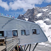
The trail starts at the end of the parking lot, in the direction of Vallon de la selle. The trail rises, revealing waterfalls and incredible flora in the middle of pastures. The last hour of the walk is more mineral and the climb up the glacial moraine more challenging. The arrival at the refuge, with its panoramic view of the glacier, lake and surrounding peaks, will reward you for your efforts.
Dogs must be kept on a leash due to the presence of herds at certain times of the year.
TO SEE ON THE ROUTE
- Aiguille du Plat de la selle
- The Selle glacier and its glacier lake
- Le Rateau
Route details
Opening
From 15/05 to 31/10 daily.
Informations to download
Discover more
Go there
Latitude : 44.963174
Longitude : 6.178104
Height : 2694
38520 Saint-Christophe-en-Oisans - La Bérarde
Go there
Dogs are allowed on a small part of the trail, but must be kept on a leash.
Information updated on 03/07/2026
by Oisans Tourisme


