



Col de Côte Belle from Valsenestre
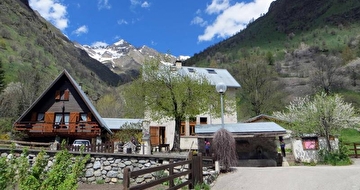
The Valsenestre Organs are a geological curiosity, the high point of trails that also offer a remarkable panorama from the col over the Valsenestre corrie and, on the other side, the Font Turbat valley.
The trail makes for a very pleasant walk. At first, it is shaded, filled with flowers for much of the summer and rises in well-marked loops to the mountains pass. The trail is a chance to immerse yourself in several natural environments, showing you how the vegetation adapts to the terrain, as you go upwards through forest, tall grassland and Alpine grasses. A big surprise, when you get to the Organs - you feel like you have arrived on another planet, the result of a natural evolution of the limestone rock and limestone schist.
Georgette Guidetti, Secretary-receptionist in Valbonnais
Route details
From the village of Valsenestre, go up the track alongside the Béranger torrent, past the limits of the National Park and you arrive at the Les Touches bridge. Continue as far as a fork and follow the path to the right. The path enters a small wood of resinous trees, then runs alongside the stream at the bottom of the gorge before finally moving away to the left as it rises in altitude. Here, you can see the torrential corrective work (wooden dams) conducted by the RTM restoration services. Continue upwards along a winding path through the forest. On the way, you will come across a fairly rare plant, the pleurospermum austriacum. Cross the high grassland, with a whole host of plants, including the aconitum variegatum and the achillea macrophylla. A little higher, you will see the Alpine columbine, after which the low-lying Alpine grass gradually replaces the forest. Continue up to the Valsenestre Organs. Through wide loops, you arrive at the mountain pass to see a very fine panorama. Follow the same route on the way back. The descent is also possible towards Le Désert en Valjouffrey.
More details
Informations to download
Tips
Is in the midst of the park : The national park is an unrestricted natural area but subjected to regulations which must be known by all visitors.
Go there
Latitude : 44.907793
Longitude : 6.054222
38740 Valjouffrey
Go there
Departure : Valsenestre.
Road access : D26 from La Mure. D526 from Pont du Prêtre. D117 from Entraigues to La Chapelle et Valsenestre..
Parking recommended : Village of Valsenestre car park. .
Information updated on 03/09/2026
by Parc national des Écrins


