



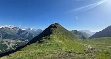
7 - The Cassini Cross as seen from the Sarenne Pass
Before your visit
The periods during which trails are accessible vary from year to year depending on snow cover and weather conditions. In addition, trail conditions can change rapidly after a weather event and are not checked daily. If you encounter a section of the trail that is in poor condition or dangerous, turn back and report it to the tourist office upon your return.
A route that’s moderately challenging in terms of endurance but very technical: a panoramic view of the entire Oisans region from the summit of the Croix de Cassini. The ridge is quite vertiginous, but it’s a perfect introduction to skyrunning!
Terrain difficulty: A steep, vertiginous trail of stone and rock along a ridge (with a few sections requiring the use of hands) on the ascent. The descent is moderately technical at first, then becomes more technical with deeply eroded, gully-like trails followed by rocks that disrupt your stride.
Terrain conditions: Stones and boulders that disrupt your stride on a steep to moderately steep slope.
The view of the five Oisans mountain ranges offers an unmissable experience: Arves, Grandes Rousses, Belledonne, Taillefer, and Ecrins. If you love vertical challenges, you’ll be in heaven. This route is typical of “skyrunning,” a sub-discipline of mountain trail running.
Route details
From the Col de Sarenne parking lot, take a trail that climbs directly to the end of the ridge toward the orientation table; simply follow the signs for “La Croix de Cassini.”
The route is then marked in yellow on the rocks along the entire length of the ridge. However, the markings may be difficult to follow because several trails intersect during the ascent.
At the rock face section, we recommend taking the left-hand route, which is more accessible, less steep, and less exposed to the drop-off.
Once you reach the summit, follow signs for “Col de Grande Pellorce”. Once you reach the pass, turn right, following “Le Sela” and “Les dessus du Sela.”
As you approach the road, turn right again, following “Col de Sarenne,” which will lead you back to your starting point.
-
Pets welcome,
-
Motorhomes allowed,
-
Drinking water
-
Play area,
-
Picnic area,
-
Bar,
-
Public WC,
-
Car park,
-
Restaurant,
-
Ping pong table,
-
Charging stations for electric vehicles,
-
Free car park
Opening
From 15/06 to 30/09 daily.
The periods during which the trails are accessible vary from year to year depending on snow cover and weather conditions. In addition, trail conditions can change rapidly after a weather event and are not checked daily. If you encounter a section of the trail that is in poor condition or dangerous, turn back and report it to the tourist office upon your return.
Subject to favorable weather.
More details
Reserved space 330 cm wide < 100 m from the site
Informations to download
Discover more
-
5 - The descent through the 21 hairpin turns of Piégut via Maronne and Les Sûres
Place: Auris-en-Oisans
Elevation 335m

-
6 - Piégut Forest and its 21 switchbacks; return via the Mine
Place: Auris-en-Oisans
Elevation 430m

-
8 - Trail ombragé dans les hameaux d'Auris
Place: Auris-en-Oisans
Elevation 550m

-
9 - Tour du Signal de l'Homme
Place: Auris-en-Oisans
Elevation 320m

Go there
Latitude : 45.056244
Longitude : 6.0782
Height : 1600
38142 Auris-en-Oisans
Go there
Place à l'entrée de la station où se trouve l'Office de tourisme.
Information updated on 24/08/2026
by Oisans Tourisme


