



Hiking La Muzelle lake and refuge

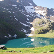
Walking to La Muzelle is a way to discover the typical landscapes of the Oisans. The height difference is impressive, but it enables you to walk through a spruce wood, then on alpine grass, and finally in the middle of a mineral cirque.
TECHNICAL INFORMATION
Start: Venosc
Elevation gain: 1,260 m
Duration (return): 7 hours
Distance: 13 km
Difficulty – technical: easy – physical: difficult
MAPS AND GUIDEBOOKS
Oisans au Bout des Pieds No. 5, trail 509
IGN TOP 25 No. 3336 AND
PLACES TO VISIT NEARBY
The village of Venosc, with its narrow cobbled streets and shops.
PLEASE NOTE
Remember that you are in the heart of the Écrins National Park; please respect the regulations.
Route details
From « l'Alleau », take direction « Refuge de la Muzelle » after the small bridge. Follow the winding path leading to the ruins of Pleney. The path continues near the torrent until le « Clot du Sella ». Cross the bridge , and follow the « ardoisières » then « les marches » before you arrive at the lake.
Accommodation
Opening
From 01/06 to 31/10/2026.
More details
Informations to download
Tips
Opportunity to spend the night at the Muzelle hut .Think to book !
if you want to hike with your baby , the tourist office rents baby carriers
Discover more


Go there
Latitude : 44.987172
Longitude : 6.116317
Height : 2100
38520 Venosc
Go there
in Bourg Arud follow the direction of the refuge and lake Muzelle
Information updated on 17/03/2026
by Office de Tourisme des 2 Alpes


