The Forest of Gillardes & The Canyon of the Infernet

Near Pellafol, this cool and peaceful route, along the banks of the Souloise, invites you to discover a geological curiosity: the sources of the Gillarde, the second largest springs in France.
Directions:
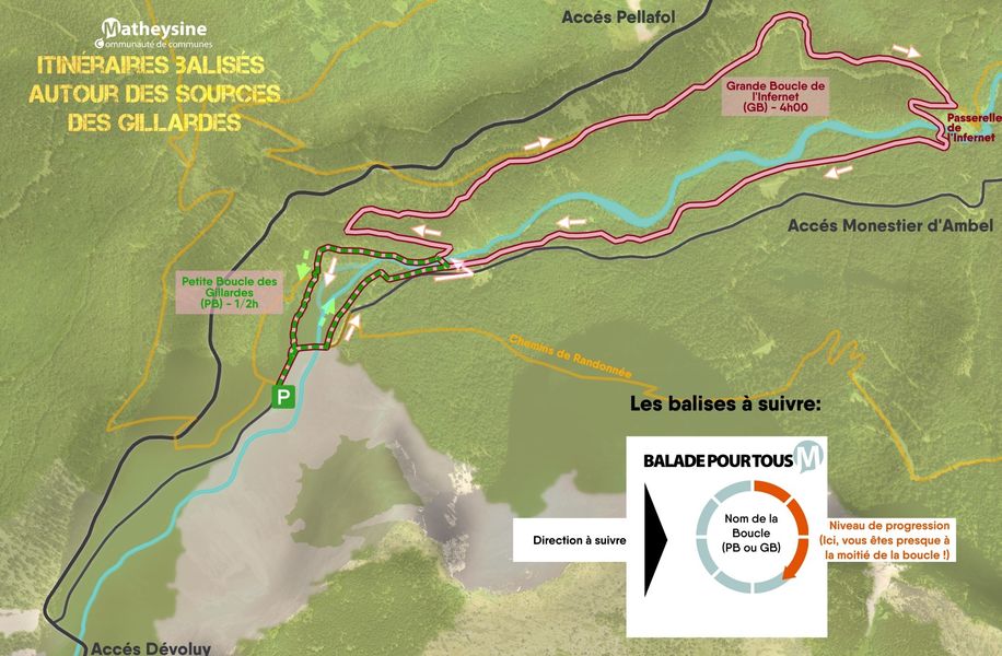
From the Gillardes parking lot, follow the road to the right, cross the bridge, then take the path on the left. About 400 meters later, leave the bridge on your left and continue along the Souloise River until you reach a footbridge. Cross this and climb the path that takes you above the Infernet Canyon. Descend a few switchbacks to get a closer look.
Return to the path you left before the small switchbacks. Follow the path on the right, cross a wide track to find a small path. A little further on, find this path at a bend and follow it for about 400 meters. The path continues to the right; take the path on the left.
At the next intersection, descend the path on the left for two switchbacks; you will find the bridge you left on your left at the beginning of the hike.
Turn right towards the Gillardes Springs. The path takes you around the springs. Leave the return path to admire this spring, nestled in the heart of the forest.
Return to the return trail and follow the parking signs on the hiking trails.
Alternative:
Take the same route to the first small footbridge, cross it, and return left to the Sources des Gillardes. Return to the parking lot via the same route as the long loop.
Follow the information signs along the entire trail.
Route details
From the parking lot of the Gillardes, follow the road going on the right, cross the bridge and take the path on the left. Around 4000m after, leave the bridge on your left and follow the path along the Souloise riverand climb the path that will bring you up to the Gorges of the Infernet.
Go down through some switchbacks to see it closer.
Way back to the path you've left before the switchbacks. Follow the path on your right, cross a large way for finding a small path. A little bit farer, find this way in a switchback and follow it around 400m. The way continues on the right, take the left path.
At the next crossroad, go down the path on the left over 2 switchbacks, you will meet again the bridge you kept on your left at the beginning.
Take to the right by following "Sources des Gillardes". The path makes you go around the Sources. Leave the way back for having a look on this resurgence , nestled in the heart of the forest.
Go back to the way back path and follow the indications of the parking lot on the panels.
Variation :
Take the same journeu until the first small footbridge., cross it and walk back by the left until the "Sources of Gillardes". the return to the parking lot follows the same way than the great loop.
Keep following the explanatory panels.
Pets welcome
Picnic area
Opening
All year round daily.
Subject to favorable weather.
More details
Not accessible in a wheelchair
Informations to download
-
The Forest of Gillardes & The Canyon of the Infernet_Monestier-d'Ambel
Document PNG 608,18 Ko -
The Forest of Gillardes & The Canyon of the Infernet_Monestier-d'Ambel
Document GPX 30,32 Ko -
Topo - La forêt des Gillardes et le canyon de l'Infernet
Document PDF 1,08 Mo -
Boucles Les Gillardes
Document PDF 2,34 Mo
Go there
Latitude : 44.758276
Longitude : 5.887787
Height : 944
Route D217
38970 Monestier-d'Ambel
Go there
From Corps, head towards the EDF dam. Cross the dam and then the hamlets of "Les Payas" and "La Posterle". Continue towards Le Dévoluy and turn left at the first intersection (about 4km after the hamlet of "La Posterle"). 700m after the turn, you will find the car park on your right.
Information updated on 22/10/2026
by Matheysine Tourisme